When the approach controller issues a clearance, “maintain 3,000 feet until established,” what does it mean to be established?
The specific meaning of this phrase is a bit more involved than a short definition, and it is critically relevant in avoiding Controlled Flight Into Terrain (CFIT) accidents.
Maintain the last altitude assigned by ATC until the aircraft is established on a published segment of a transition route, or approach procedure segment, or other published route, for which a lower altitude is published on the chart.
AIM 5-4-6 (e)(1)
In the first example of how this works, assume an airplane is vectored to the ILS 23L at KIND on a heading between the CLANG and LLARY waypoints.

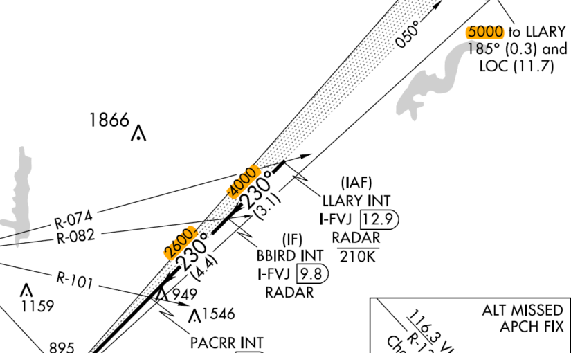
Localizer Captured, Are We Established?
The answer according to the Aeronautical Information Manual (AIM) is no, when capturing the lateral course outside the BBIRD waypoint at 3,000 ft, the airplane is not established on the approach because it is vertically below the published approach course.
In this case, the airplane may not descend below the assigned altitude of 3,000 ft until it is tracking the inbound course southwest of the BBIRD waypoint where a lower altitude is published. The airplane may descend to 2,600 ft after passing BBIRD inbound.
Glide Slope Captured, Are We Established?
If the assigned altitude is 4,000 ft, it is tempting to capture and descend on the glide slope. However, due to altimetry variations with changes in temperature and pressure, the waypoint minimum altitudes tend to move relative to the glide slope. In other words, the minimum altitude could be above the glide slope.
Interception and tracking of the glide slope prior to the published glide slope interception altitude does not necessarily ensure that minimum, maximum, and/or mandatory altitudes published for any preceding fixes will be complied with during the descent.
AIM 5-4-5 (b) Note 2
Where’s the CFIT?
Let’s change the example to KTUS with a vector to the ILS 11L. Assume an airplane is vectored between the TACUB and LIPTE waypoints at 5,500 ft.

The published ILS intercept altitude for this procedure is 4,600 ft. Terrain underlying the intermediate course of the approach rises above 4,600 ft. In this case, descending below 5,500 ft before the WASON waypoint would be extremely dangerous.
Awareness and avoidance of CFIT hazards are among several reasons why FAA procedures and clearances do not allow a descent when intercepting a localizer or published intermediate course with altitude restrictions. I am not attempting to conflate mountainous and non-mountainous scenarios. These procedures are to be flown by the same principles, and any deviation from these procedures is likely to have consequences.
Remember, if you are vectored and cleared for an approach, you are not “established” until there is a published minimum altitude lower than the assigned altitude.