I found an interesting error in Flying Magazine today, in which the author described an airplane’s range as being “anywhere from a perfect circle to an egg shape based on the wind conditions.” Wrong!
Remember, one should think in the most simple terms about the effect of wind on an airplane. Wind is just motion of the air. After an airplane leaves the ground during takeoff, it experiences no relative influence from a steady wind because the airplane is flying into the air in a manner that is constant relative to that air. From any given point in the air mass, the airplane’s range is a perfect circle within that mass.
Wind is important in flight, of course, because it modifies the ground track and speed relative to the Earth’s surface. This changes fuel requirements, and ultimately the cost and efficiency of flight between points on the surface. But what the wind does not do is create “eggs” or “semi-oval shapes”. When the wind is calm, the range circle in the air mass is identical on the ground. When the wind is 20 kt, the center of the range circle moves 20 NM away from the airplane’s initial position on the surface for each one hour of flight.
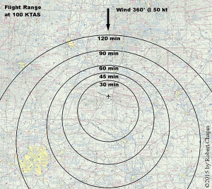
The slight asymmetry of two or more range circles is created by the fact that concentric “range rings” will be centered in different positions on the surface. As described above, if a 1-hour range ring is offset by 20 NM, then a 2-hour range ring must be offset by 40 NM, and so on. When these range rings are plotted simultaneously, they give a slight illusion of being oblong, when in fact they are still perfectly circular.
If that explanation is too simple, you can verify the wind calculations using some basic high school trigonometry.

Assuming, for simplicity, a north wind and one hour endurance, the aircraft’s range of longitude can be expressed as:
x = TAS * sine( HDG )
East and west motion will be unaffected by the wind. The aircraft’s range of latitude will be:
y = TAS * cosine( HDG ) - WIND
The north and south motion vector will be added to the wind speed, which is pushing the airplane to the south.
Total range on a specific heading will be equal to the square root of x2 + y2.
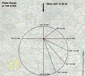
The result of these formulas is a normal circle that has been shifted to the south by a distance proportional to the wind speed. We can even confirm by using these formulas that various ground tracks created by different aircraft headings will result in the aircraft landing on points of the circle corresponding to the heading angle, exactly equidistant to the center of the circle.
My example diagrams assume an airplane overhead the Rich Mountain VOR flying at 100 KTAS with a strong wind of 50 kt from the north. In one hour, the airplane can travel 50 NM north or 150 NM south due to the wind. In 30 minutes, the airplane can travel 25 NM north or 75 NM south, and so on.
To plot your own range ring, you may easily avoid fancy trigonometry. Just remember that you can take the wind speed, multiply by the number of flight hours, and move the center of the circle that many miles in the direction the wind is blowing. The radius of the circle is the number of flight hours multiplied by the true air speed. After plotting the center and the radius, you can draw a full circle to see the range in every direction.